
cleverR insights
from data to territorial action
cleveR insights
from data to territorial action
a new way to understand, manage, and protect territories
Every day, territories generate a vast amount of fragmented data that is difficult to leverage. cleveR insights offers an integrated approach to capturing, analyzing, and enhancing territorial data, enabling local authorities to act faster and more effectively.
of residents of the Paris region (3.6 million people) live in vulnerable urban heat islands.
annual deaths are linked to fine particulate pollution in France.
of natural disasters are caused by urban runoff.

a sovereign architecture serving local authorities
Faced with pollution, noise, infrastructure degradation, and extreme climate events, public stakeholders need a comprehensive, continuous, and actionable view to inform and accelerate decision-making.
With cleveR insights, Software République relies on a modular and sovereign architecture designed to evolve dynamically and integrate new use cases, data sources, and collaboration models.
understand on the territory
Through real-time data collection and analysis, cleveR insights delivers a global and dynamic view of the territory, helping anticipate risks, simulate impacts, and trigger fast, coordinated actions for more efficient and sustainable management.

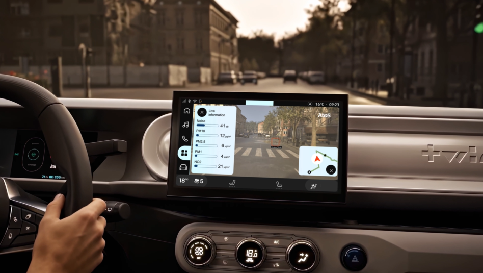
the vehicle becomes a territorial sensor
Equipped with the cleveR insights suite, the Twingo turns into a mobile observation point. Environmental sensors, augmented vision, and embedded AI — every journey continuously enriches territorial knowledge.
an integrated approach in three steps
From observation to action, cleveR insights brings together three complementary capabilities to support local authorities.
see the invisible
Capture and cross-reference fragmented data to make the unseen visible.
cleveR insights is based on collecting and combining data from fixed and mobile sensors, satellites, citizen contributions, and field observations — all integrated within an open and secure architecture.

activate mobility
Turn every vehicle into a mobile observation point and every journey into a data source.
Everyday vehicles, dedicated fleets, or connected citizens — mobility becomes a sensor. This densification of observations enables a real-time, granular, and contextualized understanding of the territory.
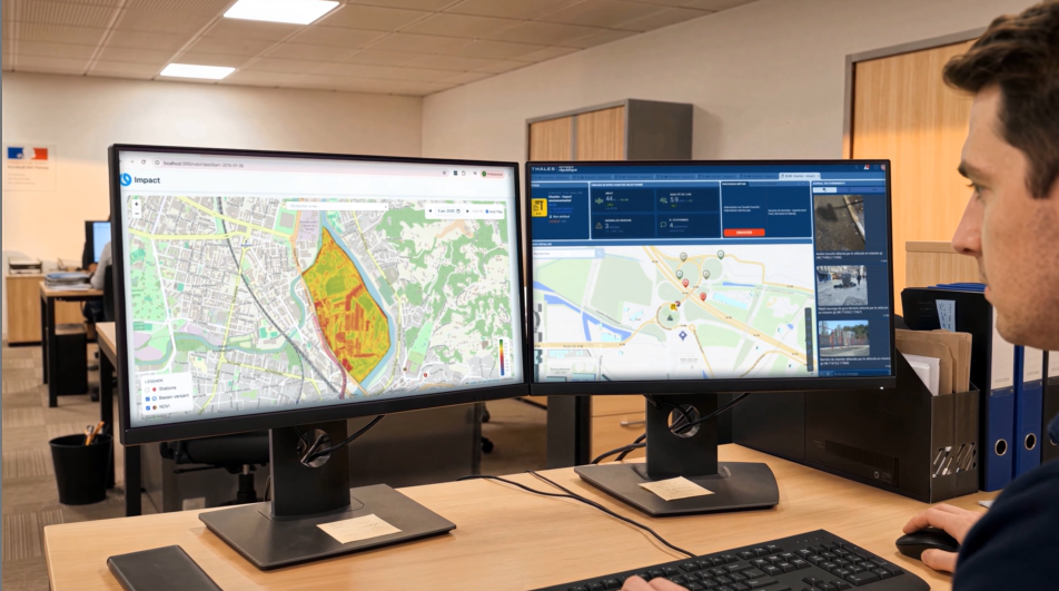
decide in real time
Transform scattered data into coordinated, operational, and sustainable decisions.
Aggregated within a sovereign platform, data is delivered through dynamic maps, dashboards, and shared indicators — enabling prioritization, coordination, and anticipation.
an open collaborative dynamic
Founding members, experimental territories, academic research, environmental observatories, and deeptech startups combine their expertise to bring cleveR insights to life.


six areas of expertise serving the territory
Each partner contributes a specific capability — observation, data capture, artificial intelligence, or operational management.

Paris-Saclay
A major experimental territory leading urban planning and sustainable mobility initiatives across 27 municipalities within a global science hub.
Atmo Sud
The national federation of air quality observatories responsible for monitoring, forecasting, and supporting decision-makers in reducing exposure to pollutants.
Bruitparif
A leading technical observatory in Île-de-France that measures noise pollution and helps local authorities develop policies for a calmer sound environment.
Veolia
A global leader in water, waste, and energy management, developing solutions to accelerate the ecological transition of territories and industries.
Join the collaborative innovation
Local authorities, partners, or journalists: let’s talk about how sovereign data is transforming territories.